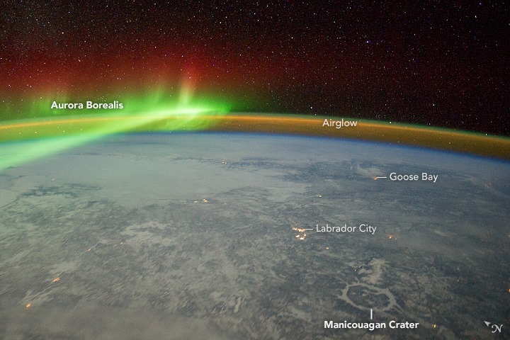
When a member of NASA’s Expedition 30 crew looked out of the window of the International Space Station on February 3, 2012, he witnessed beautiful green veils and curtains of the aurora borealis (northern lights) spanning thousands of exceptional kilometers over Quebec, Canada. So he grabbed his Nikon D3S with 28 millimeter lens, enabling him to capture this stunning picture, eventually named “ISS030-E-110900.”
The aurora borealis is the light that glows when charged particles from the magnetosphere (the magnetic space around Earth) are accelerated by storms from the Sun. The particles collide with atoms in the atmosphere – the green and red colors, for instance, are caused by the release of photons by oxygen atoms. The fainter arc of light that parallels the horizon is known as “airglow.” This is another manifestation of the interaction of the Earth’s atmosphere with radiation from the Sun.
The snow and ice in this winter image also reflect enough light from stars, the Moon and the aurora to reveal details of the landscape below. Therefore, on the lower right, a circle of ice is visible on the frozen reservoir that now occupies Manicouagan impact crater (70 kilometers in diameter), created roughly 214 million years ago. The impact caused a shock wave to radiate across Earth’s surface, followed closely by high-velocity winds. Near the impact point, wind speeds would have exceeded 1,000 kilometers (600 miles) per hour.
City lights also reveal small settlements, such as Labrador City (an iron-ore mining town) and the Royal Canadian Air Force base at Goose Bay on the Labrador Sea.
The ISS030-E-110900 “has been cropped and enhanced to improve contrast, and lens artifacts have been removed,” NASA’s Earth Observatory explains, and you can download different sizes right here. Additional images taken by astronauts and cosmonauts can be viewed at the Gateway to Astronaut Photography of Earth website.

